
Two of the largest independently produced open knowledge initiatives on the internet describe the same world in different ways. One is OpenStreetMap (OSM), a community map that goes from country borders and roads down to intersections, public bathrooms, and street-corner trash cans. The other is the Wikimedia projects: Wikipedia, Wikidata, and Wikivoyage describe those same places in words. The two already point at each other, with Wikidata items carrying OSM identifiers and OSM features tagged with Wikipedia and Wikidata links, but their data structures are so different that joining them at scale has taken geographic information systems (GIS) expertise and custom pipelines.
Wikimedia Enterprise has released an open geospatial dataset that does that join: 17 million OpenStreetMap elements linked to Wikidata, Wikipedia, and Wikivoyage, as Parquet and GeoParquet files on Hugging Face and Kaggle. Developers, cartographers, AI researchers, and open-source contributors can query geographic and semantic data together without building the pipeline themselves.
The dataset was built by Michal Migurski, a longtime member of the OpenStreetMap community and contributor to geospatial software.
"You often see references to Wikipedia or Wikidata entities inside of OpenStreetMap tags. And then you encounter the same thing on the other side with references to OpenStreetMap elements in Wikidata or Wikivoyage. What you don't see is many datasets that fully expand those connections in both directions. So I created linked tables that surface those connections for easy reuse by anyone."
- Michal Migurski
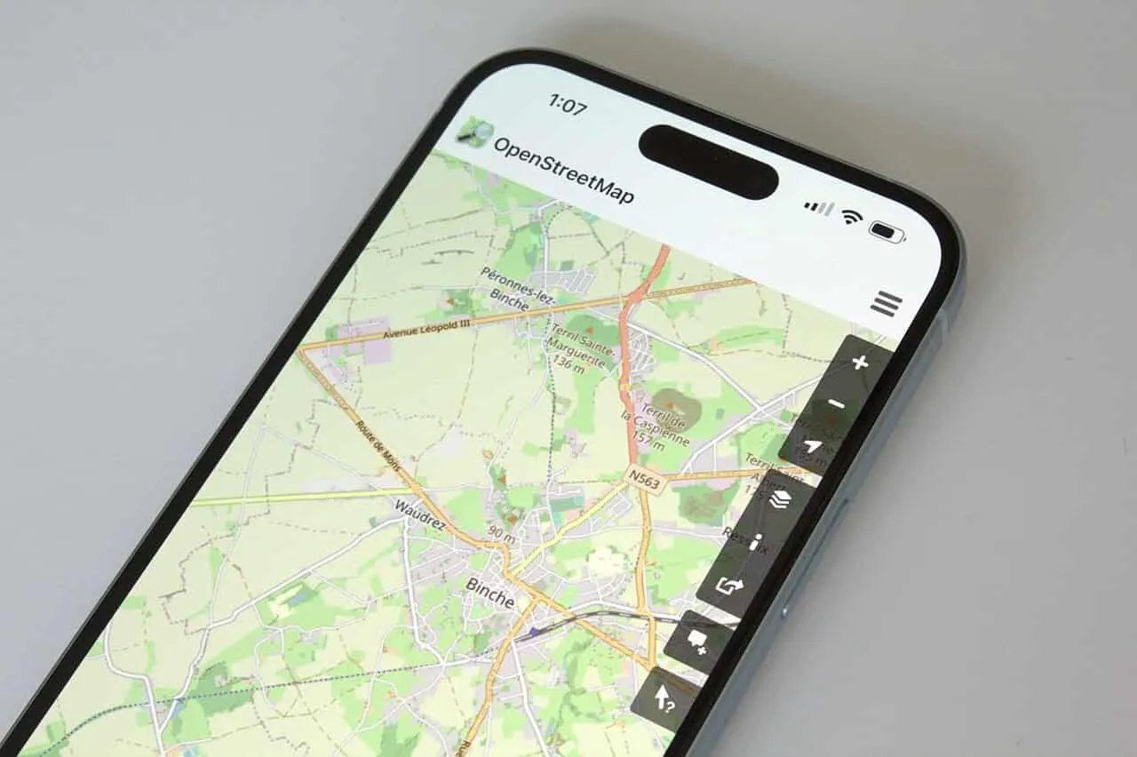
Photo: OpenStreetMap on an iPhone 15 Plus, by Infinite Bed, CC BY-SA 4.0

Link spatial features to human knowledge
This dataset is particularly interesting for two types of reusers:
- GIS experts: engineers building base maps, outdoor routing apps, or navigation platforms rely on OpenStreetMap for spatial geometries, but often lack context regarding which points of interest (POIs) are significant, historically notable, or accompanied by rich media.
- Semantic knowledge developers: teams working with large textual corpora or knowledge graphs understand Wikidata QIDs and Wikipedia articles. It's often challenging to map, parse, and integrate geospatial data into these knowledge graphs.
This dataset brings both worlds together into a central reference system. At its core is a links.parquet table that maps Wikidata QIDs directly to OpenStreetMap nodes, ways, and relations, alongside the original source tags that established the link.
Whether a developer is building a hiking app that surfaces the Wikipedia article of the mountain peak a hiker is climbing right now, or a corpus linguistics researcher conducting spatial analysis of place names and their histories, the pre-joined dataset removes the work of building custom data pipelines from scratch.
This dataset unlocks the ability to ask spatial analysis questions backed up by Wikimedia project knowledge and structured Wikidata links: What are the opening hours of all museums in a twenty-mile radius of the geographic center of Berlin? How many churches from the 17th century are close to functioning public cemeteries? Questions that need structured knowledge bases and geospatial data become answerable by connecting Wikidata, Wikipedia, Wikivoyage, and OpenStreetMap.
What is in the dataset?
"I started with Wikipedia as an entry point. After exploring Wikimedia Enterprise API endpoints and learning about the full project catalog from the Wikimedia Enterprise team, I branched out to Wikivoyage for destination-based knowledge and Wikidata as the central linking database for all Wikimedia projects. I then worked outwards from Wikidata, exploring the dense network of connections between Wikidata, Wikimedia projects, and OpenStreetMap."
- Michal Migurski
The dataset consists of six unified Parquet files, optimized for analytical queries with DuckDB, Pandas, Polars, or Apache Spark.
The main table is links.parquet (174 MB). It contains 24 million links connecting Wikidata items (QIDs), OpenStreetMap element IDs, Wikipedia article page IDs, and Wikivoyage page IDs.
The other five datasets are snapshots of OpenStreetMap, Wikidata, Wikipedia, and Wikivoyage, reflecting what data was available in these projects on September 15, 2026.
openstreetmap.parquet(36 GB GeoParquet): Includes 17 million geolocated OSM elements, complete with freeform tags, bounding boxes, and unprojected geometries.wikidata.parquet&wikidata_locations.parquet(1.4 GB total): Covers 13 million Wikidata items and 13 million explicit coordinate locations.wikipedia.parquet(22 GB): Contains 1.5 million geolocated English Wikipedia articles, including lead abstracts, raw wikitext, and fully rendered HTML.wikivoyage.parquet(515 MB): Encompasses 31,000 English Wikivoyage travel guide articles.
How the tables connect
Every row in links.parquet pairs a Wikidata QID with an OpenStreetMap element, a Wikipedia article, or a Wikivoyage article, and a source column records where the link came from. osm_wikidata means an OpenStreetMap element names the item in its wikidata tag. wikidata_p402 means the Wikidata item names an OpenStreetMap relation. main_entity means a Wikipedia article names the item as its main entity. wikidata_sitelink_wikivoyage means the item links to a Wikivoyage article. Because every table carries the QID, any two of them join through it.
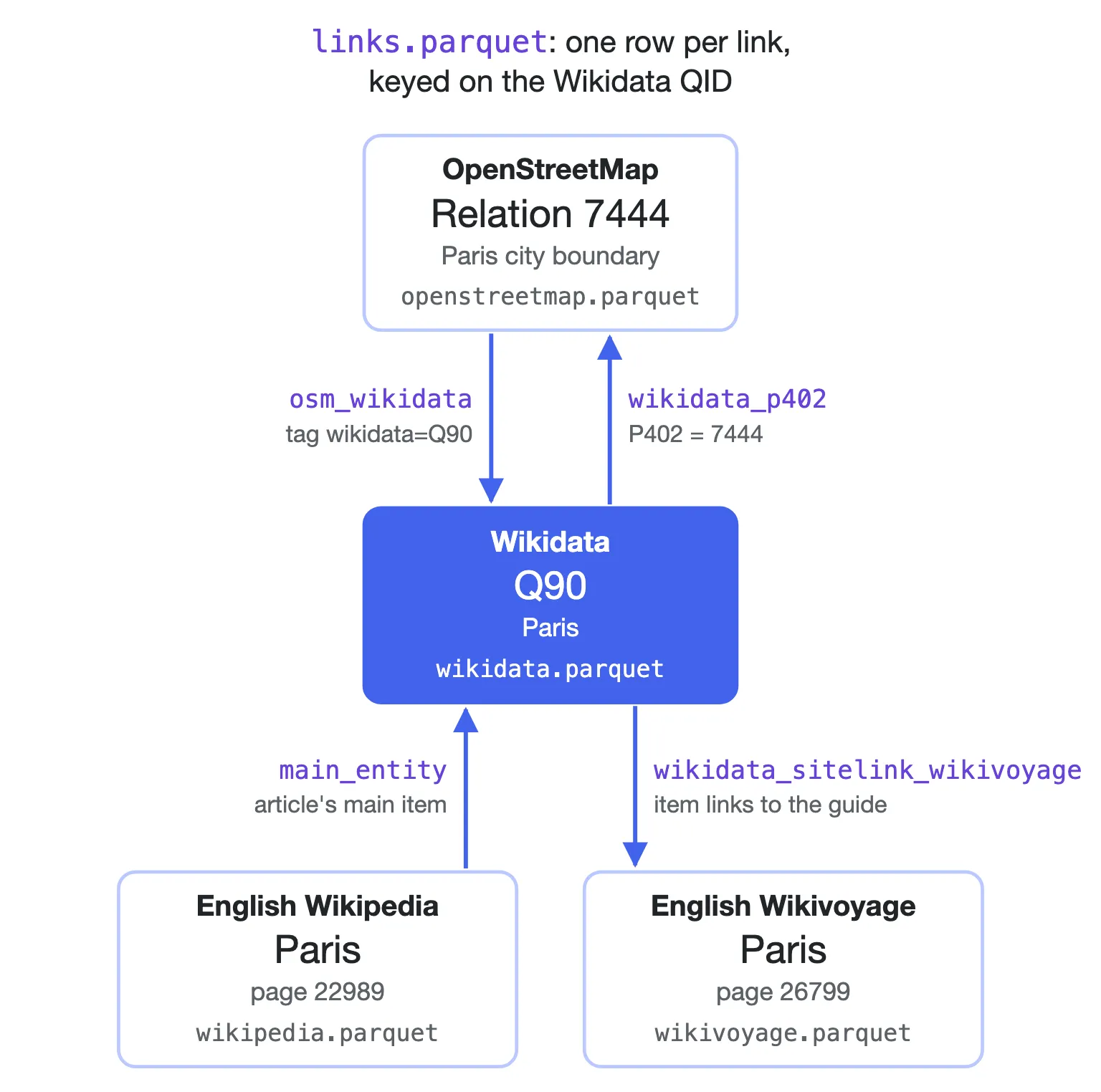
How Paris links across the four sources. Labels are source values in links.parquet. Diagram: Wikimedia Enterprise
wikidata.parquet also gives each item a QRank score, a global popularity score that ranks how prominent it is. Combined with the OpenStreetMap geometries, that answers questions such as which places in a neighborhood matter most. This DuckDB query from the dataset card ranks the places inside the Quartier du Gros-Caillou in Paris:
WITH box AS ( SELECT bbox FROM read_parquet('openstreetmap.parquet') WHERE osm_type = 'relation' AND tags['wikidata'] = 'Q3413275' -- Quartier du Gros-Caillou LIMIT 1)SELECT w.label, w.qrank, o.osm_type, o.osm_id, o.urlFROM read_parquet('openstreetmap.parquet') o, boxJOIN read_parquet('wikidata.parquet') w ON w.wikidata_id = o.tags['wikidata']WHERE o.tags['wikidata'] IS NOT NULL AND o.bbox.xmin >= box.bbox.xmin AND o.bbox.xmax <= box.bbox.xmax AND o.bbox.ymin >= box.bbox.ymin AND o.bbox.ymax <= box.bbox.ymax AND w.qrank IS NOT NULLORDER BY w.qrank DESCLIMIT 10The Eiffel Tower comes out on top, followed by the Organisation internationale de la Francophonie and the Champ de Mars.
Opportunities for stronger linking and further exploration
The links in this dataset are useful to the Wikimedia and OpenStreetMap communities as well as to third-party reusers. CoMaps, a navigation app built on OpenStreetMap, already uses the Wikipedia and Wikimedia Commons links stored in OpenStreetMap. This dataset expands those links in both directions.
One opportunity is to use these links to get insight into how complete an OSM region is, or how complete a Wikimedia project topic is. It shows where strong links already exist between projects and topics, and therefore also the interlinking gaps that community members can tackle. Wikipedia lists and Wikidata classifications (such as national parks, historic monuments, or river systems) can serve as a benchmark to identify missing features or incomplete tags in OpenStreetMap, and vice versa.
Wikivoyage editors could use the links between a Wikidata item and its OSM entity to extract useful structured information about a place (like its geographic center and boundaries) and display it on a map within Wikivoyage.
Wikidata offers many other pathways that can be followed that haven't been explored in this dataset: one look at the 'Identifiers' section of any geographical location on Wikidata shows the wealth of other linked datasets that can be reused for a variety of use cases.
"I noticed really early on in the process that there are actually a lot of pathways that we could follow that we're just not following yet. There are so many things that are linked from Wikidata that we're not really digging into yet. Once you have your hands around Wikidata, there are myriad different ways that we can get valuable geospatial insights."
- Michal Migurski
Open licensing and attribution
All datasets used to create this combined dataset are governed by open and permissive licenses, although the exact license of each data source is slightly different. This dataset signposts the licenses of its different parts, so you have clear guidance on how you're allowed to reuse any element.
links.parquet,wikidata.parquet, andwikidata_locations.parquetare dedicated to the public domain under the Creative Commons CC0 Waiver.openstreetmap.parquetis licensed under the Open Database License (ODbL), requiring attribution to OpenStreetMap contributors and ShareAlike distribution for derived data.wikipedia.parquetandwikivoyage.parquetare licensed under the Creative Commons Attribution-ShareAlike 4.0 (CC BY-SA 4.0) license.
Get started today
The complete open dataset is available immediately on Hugging Face and Kaggle. You can query the files directly using SQL in DuckDB or load them into your preferred data science framework. Find example SQL queries in the data cards on Hugging Face and Kaggle.
To recreate these source datasets from Wikimedia project sources, or to get the latest updated version of these derived datasets:
Extract the latest snapshot of all of English Wikipedia using the Snapshot Download endpoint, and find its connections to Wikidata QIDs in the main_entity field:
curl -X GET "https://api.enterprise.wikimedia.com/v2/snapshots/enwiki_namespace_0/download" \ -H "Authorization: Bearer ACCESS_TOKEN" \ --output enwiki_namespace_0.tar.gzExtract the latest snapshot of all of Wikidata's Main Graph using the Wikidata Snapshot Download (Beta) endpoint, and find its connections to OSM entities in statements using the OpenStreetMap relation, way, and node ID properties (P402, P10689, P11693). Connect a Wikidata entity to Wikipedia or Wikivoyage using the sitelinks object.
curl -X GET "https://api.enterprise.wikimedia.com/v2/snapshots/wikidata/items/download" \ -H "Authorization: Bearer ACCESS_TOKEN" \ --output wikidata_items.tar.gzExtract the latest snapshot of all of English Wikivoyage using the same Snapshot Download endpoint:
curl -X GET "https://api.enterprise.wikimedia.com/v2/snapshots/enwikivoyage_namespace_0/download" \ -H "Authorization: Bearer ACCESS_TOKEN" \ --output enwikivoyage_namespace_0.tar.gzDownload the latest complete copy of OpenStreetMap, the planet file (about 95 GB):
curl -X GET "https://planet.openstreetmap.org/pbf/planet-latest.osm.pbf" -L \ --output planet-latest.osm.pbfTo learn more about the map data, visit OpenStreetMap. To learn more about downloading full snapshots or connecting to live updates, explore the Wikimedia Enterprise Documentation or browse the Wikimedia Enterprise Project Data Overview. Get access to all of the data with a free Wikimedia Enterprise account, or contact our team to talk about high-volume access.
- Wikimedia Enterprise Team
Photo Credits
Manuscript painting of the Heezen-Tharp World ocean floor map, by Marie Tharp, Bruce Heezen, and Heinrich Berann, CC BY-SA 4.0
